Subscribe to our social channels to get the latest news about Hungary!


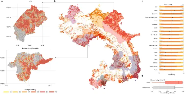
A groundbreaking study by researchers from Corvinus University of Budapest has unveiled the most fire-prone zones across the Carpathian Mountains, revealing that Borsod-Abaúj-Zemplén and Heves counties in Hungary are among the areas facing the highest wildfire risks.
Published in Scientific Reports, part of the Nature portfolio, the research introduces a comprehensive wildfire forecasting system developed by Melinda Manczinger, László Kovács, and Tibor Kovács.
Using 27 environmental and socio-economic variables, the team compiled an extensive database covering climate, vegetation, terrain, and human factors across a 210,000 km² region. Their analysis included 5,173 recorded fire incidents between 2010 and 2020 within the Carpathians.
With the help of machine learning, the researchers produced one-square-kilometre-scale risk maps, enabling them to predict where fires are most likely to occur and which factors drive these events.
The study revealed eight major fire-risk clusters, several of which cross national borders. Significant fire corridors were detected along:
Within Hungary, Borsod-Abaúj-Zemplén and Heves emerged as the most vulnerable counties.
According to lead author Melinda Manczinger, “The fire risk in the Carpathians is substantial and cannot be treated as an isolated issue. Effective prevention requires coordinated, proactive action among the affected countries.”
The study highlights that human activity is the dominant cause of vegetation fires. The presence of croplands, proximity to settlements, and population density were found to be key contributors to fire outbreaks.
Topographical factors also play a crucial role. The foothills and low-lying zones of the Carpathians—covering about one-third of the total area—showed a higher probability of wildfires.
The distance from water bodies emerged as a strong risk factor, particularly in Serbia, Romania, and Hungary. Naturally, hotter and drier weather further elevates the danger.
As climate change brings drier summers and frequent heatwaves, mountain ecosystems like the Carpathians face mounting pressure. While occasional fires can support ecological renewal, the increasing frequency and severity now threaten forests, agriculture, and tourism.
“The advantage of our model is its ability to focus on smaller regions,” Manczinger noted. “It reveals local characteristics that might otherwise be invisible at larger scales, offering a practical basis for regional prevention and planning.”
Given that many fire corridors span multiple borders, the researchers emphasize the need for integrated early warning systems, joint fire management planning, and shared rapid-response capabilities among Central and Eastern European nations.
Their interactive wildfire forecast maps for the entire Carpathian region, as well as Borsod-Abaúj-Zemplén and Lviv counties, provide detailed visual insights into where future fires are most likely to occur.


