Getting around Budapest is quick and straightforward once you understand the metro system. Checking a metro map before you travel can save time, avoid unnecessary changes and help you reach the city’s main attractions with ease.
The Hungarian capital’s metro network is clean, affordable and well connected to trams, buses and suburban trains, making it one of the most convenient ways to move around the city. Whether you’re commuting, sightseeing or heading to the airport, the metro service is often the fastest option.
Here’s everything you need to know about reading the Budapest metro map, buying tickets and navigating stations confidently.
Contents of our guide
Understanding the Budapest metro map
At first glance, the metro map may look simple compared to larger European systems, and that’s because it is. Budapest currently has four metro lines, each marked with a number and colour. Lines intersect at key stations in the city centre, making transfers easy.
The four lines are:
M1 (yellow)
M2 (red)
M3 (blue)
M4 (green)
Most maps are displayed inside stations, on platforms and inside trains, and you’ll also find digital versions in transport apps and at ticket machines. Stops are clearly labelled, and announcements are usually made in both Hungarian and English.
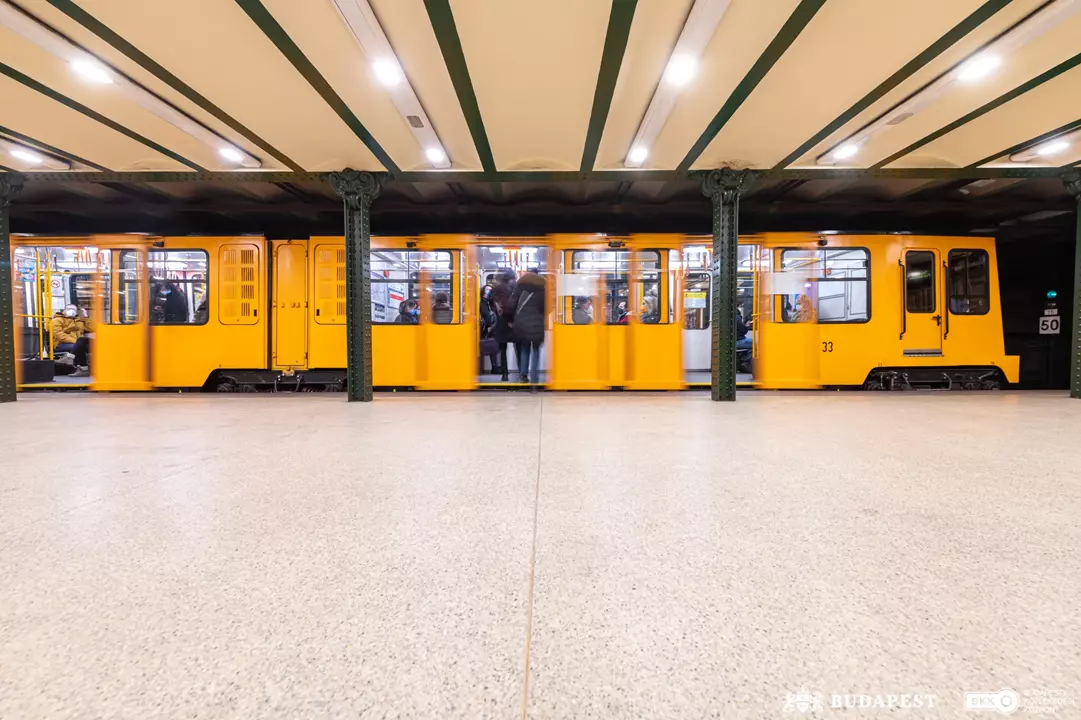
The M1 is the oldest metro line in continental Europe and runs beneath Andrássy Avenue. It connects the city centre with Heroes’ Square and City Park. The trains are smaller and the stations have a charming, historic look, making the ride an attraction in itself.
The red line links Buda and Pest, crossing under the Danube. It’s useful for reaching major railway hubs and shopping areas. Many travellers use this line daily because it passes through several busy interchange stations.
The blue line is one of the most important routes for locals. It connects residential districts with the centre and is handy for travellers heading towards outer neighbourhoods or business areas.
The newest line features modern stations, lifts and air-conditioned trains. It’s popular with commuters and connects key transport hubs on the Buda side.
All services are operated by Budapest Transport Centre (BKK), which manages public transport across the city.
Buying tickets and using the service
Budapest’s metro service operates daily from early morning until late evening, with frequent trains throughout the day. During peak hours, trains usually arrive every 2–5 minutes.
Tickets can be purchased:
from ticket machines at every station
at customer service counters
via mobile apps
You can choose single tickets, day passes or multi-day travel cards. If you plan to use the metro, trams and buses frequently, a 24-hour or 72-hour pass is often the best value.
Remember to validate your ticket before boarding or show your pass if inspected.
What to expect at stations and on trains
Each metro station is clearly marked, with signs pointing to platforms, exits and connections. Larger interchange stations may have escalators, lifts and multiple entrances, so follow the colour-coded signs that match your metro line on the map.
Trains are generally safe, clean and punctual. During rush hour, they can get busy, but outside peak times, travel is comfortable. Most stations have shops, ticket machines and helpful staff nearby.
Why the metro is ideal for visitors
For tourists, the metro is often the quickest way to reach popular sights, shopping areas and railway stations. It avoids traffic jams and removes the stress of parking in the city centre.
It’s also:
cheaper than taxis
faster than buses in rush hour
easy to understand with a simple map
well connected to other transport options
Even if you only stay a few days, learning the metro map will make exploring Budapest much easier.
If you want a smooth and stress-free way to travel around the Hungarian capital, the metro is your best friend. Spend a few minutes studying the metro map, identify your nearest station and plan your route in advance. With frequent trains, reliable service and straightforward connections, Budapest’s metro system makes city travel simple for everyone.
Budapest’s metro map: Frequently asked questions
Where can I find the Budapest metro map?
You’ll find the metro map inside every station, on platforms and inside trains (and in this article). Digital versions are also available at ticket machines and in public transport apps, making it easy to plan your route before travelling.
How many metro lines are there in Budapest?
Budapest currently has four metro lines (M1, M2, M3 and M4). Each line is colour-coded on the map, and major stations allow quick transfers between trains.
How often do metro trains run?
The metro service is frequent throughout the day. During peak hours, trains usually arrive every 2–5 minutes, while evenings and weekends may have slightly longer intervals.
Do I need a ticket for every journey?
Yes, you must have a valid ticket or pass before entering the metro. You can buy single tickets, day passes or travel cards at machines or counters in every station. If you plan multiple trips, a daily or multi-day pass is often cheaper.
Is the Budapest metro easy for tourists to use?
Yes. Stations are clearly signposted, many announcements are in English and the system is simple compared to larger cities. With a quick look at the metro map, most visitors can navigate the network without difficulty.


 ZH
ZH IT
IT DE
DE